Rain, Snow and Wind Expected Across Southern Oregon This Week
Winter Storm Watch issued for Cascades as travel impacts possible
MEDFORD, Ore. — A changing weather pattern is expected to bring widespread rainfall, mountain snow, and gusty winds across Southern Oregon and Northern California this week, according to the National Weather Service in Medford.
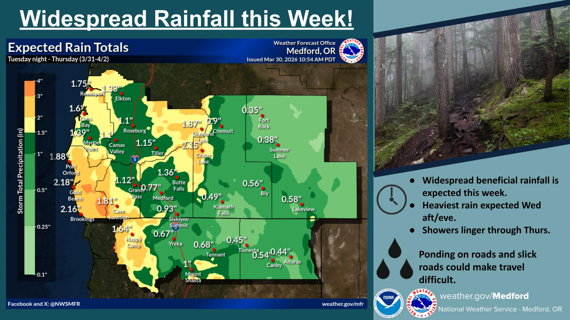
Forecasters say beneficial rainfall is expected through Thursday, with the heaviest rain anticipated Wednesday afternoon and evening. Officials note that ponding on roadways and slick conditions could make travel difficult at times.
Snow is also expected to return to the mountains beginning Wednesday as a strong weather system moves through the region. Snow levels are forecast to hover between 5,000 and 6,000 feet through Tuesday, then lower to 4,500 to 5,000 feet Tuesday night into Wednesday. By late Wednesday into Thursday, snow levels are expected to drop sharply to around 2,500 to 3,000 feet.

Snow Returns Wednesday (National Weather Service)
Meteorologists say snowfall rates could reach up to one inch per hour Wednesday night into early Thursday, potentially creating hazardous travel conditions in higher elevations. Drivers are encouraged to check road conditions before traveling through mountain passes.
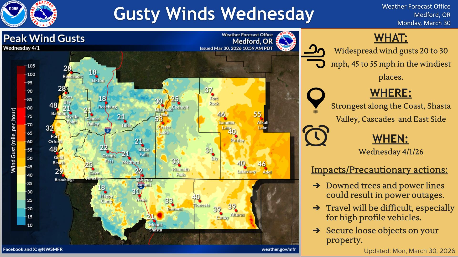
In addition to rain and snow, a strong front is expected to bring gusty winds Wednesday afternoon. Widespread wind gusts of 20 to 30 mph are forecast, with peak gusts between 45 and 55 mph possible in wind-prone areas. Residents are advised to secure loose outdoor objects.
The National Weather Service has also issued a Winter Storm Watch for portions of the southern Oregon Cascades and eastern Douglas County foothills from late Tuesday night through Thursday afternoon.
The watch includes areas such as Crater Lake, Diamond Lake, Union Creek, Toketee Falls, and Crescent Lake, as well as mountain passes along highways 140, 62, 138, 230, and 58.
Forecasters say heavy snow accumulations of 10 to 20 inches are possible in the affected areas, with wind gusts up to 40 mph over high and exposed terrain. Travel in these areas may become very difficult to impossible, particularly during the Wednesday morning and evening commutes.
Officials recommend monitoring the latest forecasts for updates as conditions evolve.
Cover image: AI Generated

Winter Storm Watch
URGENT - WINTER WEATHER MESSAGE
National Weather Service Medford OR
1009 AM PDT Mon Mar 30 2026
Eastern Douglas County Foothills-South Central Oregon Cascades-Siskiyou Mountains and Southern Oregon Cascades
Including the following locations...Crescent Lake, Toketee Falls, Crater Lake, Diamond Lake, and Union Creek
10:09 AM PDT Mon Mar 30 2026
WINTER STORM WATCH IN EFFECT FROM LATE TUESDAY NIGHT THROUGH THURSDAY AFTERNOON
WHAT...Heavy snow possible. Total snow accumulations 10 to 20 inches possible. Winds could gust as high as 40 mph over high and exposed terrain.
WHERE...The southern Oregon Cascades north of Howard Prairie Lake, and the eastern Douglas County Foothills above 3000 ft, including the passes along highways 140, 62, 138, 230, and 58.
WHEN...From early Wednesday morning through Thursday afternoon.
IMPACTS...Travel may be very difficult to impossible. The hazardous conditions could impact the Wednesday morning and evening commutes.
PRECAUTIONARY/PREPAREDNESS ACTIONS
Monitor the latest forecasts for updates on this situation.