Winter Storm Pattern to Bring Heavy Mountain Snow, Hazardous Travel, and Dangerous Surf
Snow levels falling sharply midweek as multiple systems move through Southern Oregon
Southern Oregon — A series of winter weather systems moving through the region this week is expected to bring falling snow levels, hazardous travel conditions across mountain passes, and dangerous surf along the coast.
The first system is forecast to arrive Tuesday night, followed by a second front late Wednesday. Snow levels are expected to lower from approximately 3,500 to 4,000 feet Tuesday night and Wednesday, dropping further to 1,500 to 2,500 feet by Wednesday night.
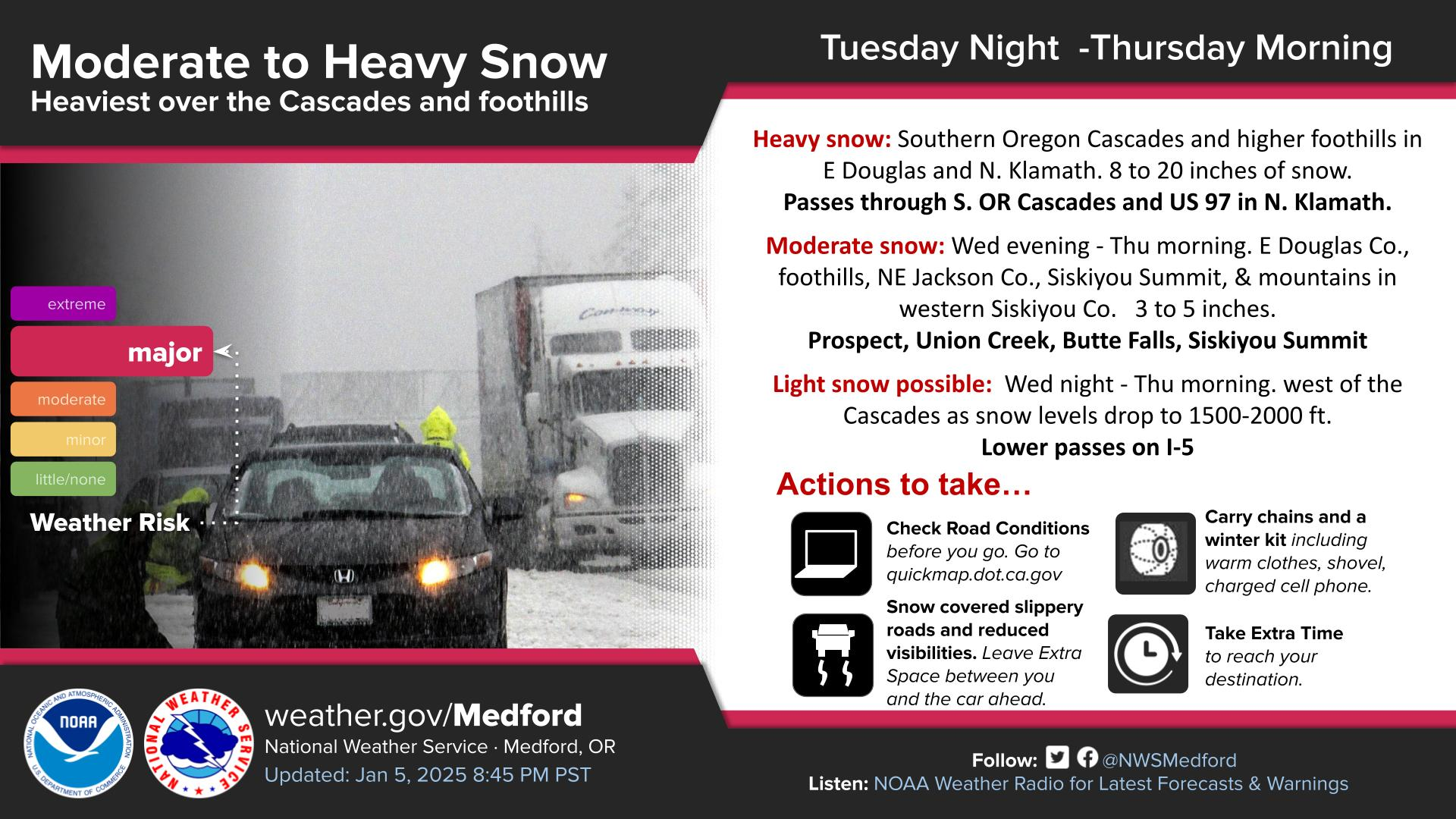
Heavy snow is expected to impact mountain passes in the Southern Oregon Cascades, as well as foothill areas of eastern Douglas County above 3,000 feet and northern Klamath County. Moderate snowfall is forecast for the lower foothills of eastern Douglas County, northeastern Jackson County, Siskiyou Summit, and the mountains of western Siskiyou County.
Forecasters say light snow may reach lower-elevation passes along Interstate 5 Wednesday night, potentially affecting overnight and early morning travel.
A stronger cold front is expected to arrive Wednesday afternoon and continue into Thursday morning. Snow levels will initially remain near 3,500 feet, then fall to 1,500 to 2,000 feet by Thursday morning. Heavy snowfall is anticipated across the Cascade range, with lighter snow possibly reaching some lower elevations. Travel across Cascade passes during this period may become difficult to impossible.
Drivers are urged to use caution if travel is necessary. Officials recommend checking road conditions before departing, carrying chains and a winter emergency kit, allowing extra following distance, and planning additional travel time due to snow-covered and slippery roads.
In addition to inland impacts, dangerous marine conditions are expected along the southern Oregon coast. A large, long-period swell originating near the Aleutian Islands is forecast to arrive Wednesday morning and persist through Thursday night. Breaking waves of 22 to 26 feet are possible, creating hazardous surf conditions.
Beachgoers are urged to stay well away from the surf zone, avoid jetties, and maintain a safe distance from the shoreline, as conditions may change rapidly.
Mountain Snow and Travel Impacts
The first front is expected to arrive Tuesday night, followed by a second and colder system late Wednesday into Thursday morning. Snow levels are forecast to start around 3,500 to 4,000 feet, then drop sharply to 1,500 to 2,000 feet by Thursday morning, allowing snow to reach lower elevations.
Heavy snowfall totals of 8 to 20 inches are expected across:
The Southern Oregon Cascades
Higher foothills of eastern Douglas County
Northern Klamath County
Passes through the Cascades, including U.S. 97 and higher mountain routes
Moderate snowfall of 3 to 5 inches is forecast for:
Lower foothills of eastern Douglas County
Northeastern Jackson County
Siskiyou Summit
Mountains of western Siskiyou County
Communities such as Prospect, Union Creek, and Butte Falls
As snow levels fall Wednesday night, light snow may reach lower-elevation passes along Interstate 5, increasing the potential for slick roads and reduced visibility overnight and into early Thursday.
Travel over the Cascades during this period may become difficult to impossible, particularly during periods of heavy snowfall.
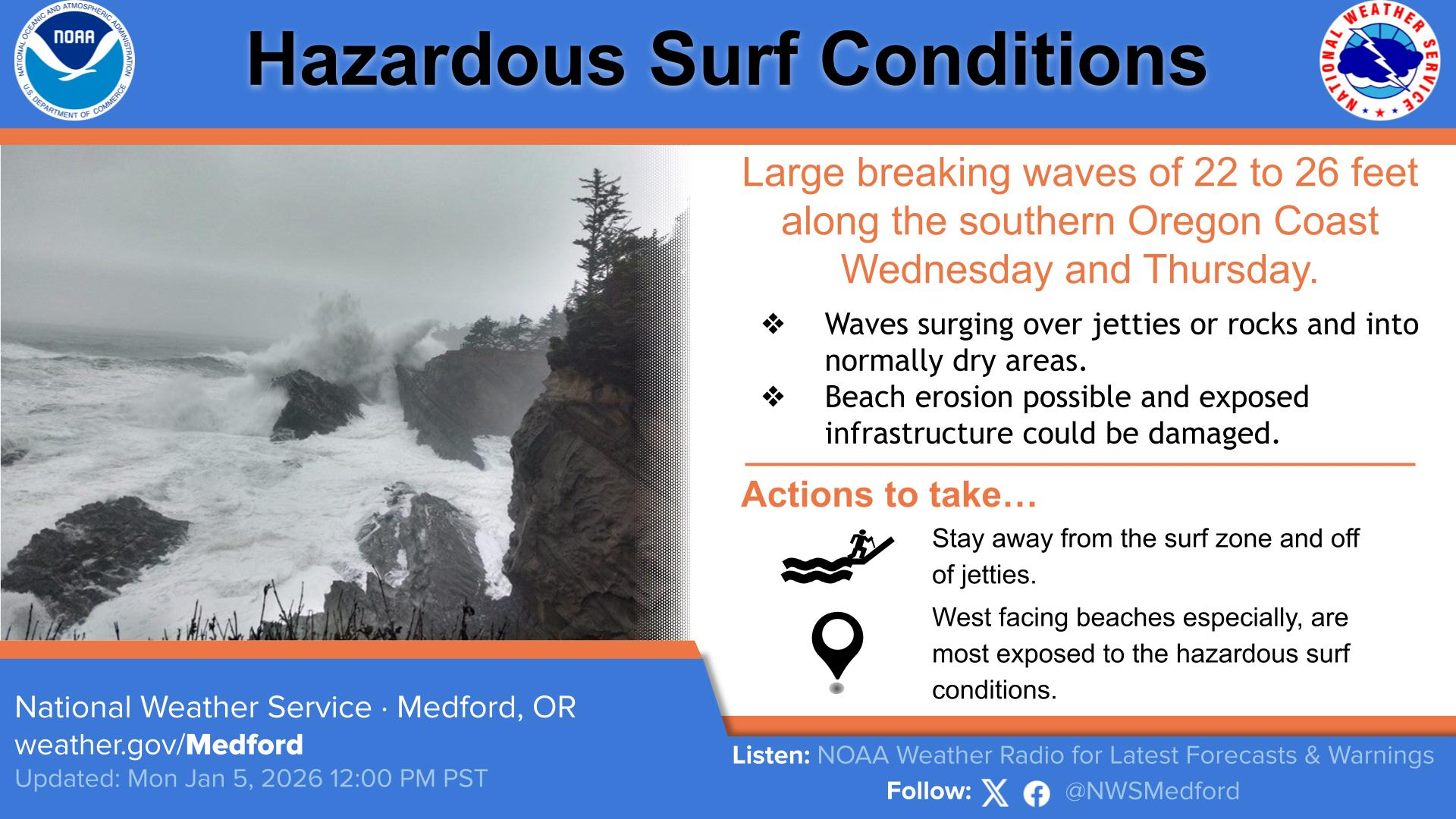
Coastal Hazards: Dangerous Surf Expected
In addition to inland impacts, a large, long-period swell originating near the Aleutian Islands is expected to produce hazardous surf conditions along the southern Oregon coast from Wednesday morning through Thursday night.
Forecasts call for breaking waves of 22 to 26 feet, with the potential for:
Waves surging over jetties and rocky outcroppings
Water reaching areas normally considered dry
Beach erosion and possible impacts to exposed infrastructure
Officials strongly advise the public to stay well away from the surf zone, avoid jetties entirely, and maintain a safe distance from the shoreline, especially along west-facing beaches, where exposure will be greatest.
Safety Recommendations
If travel is necessary, drivers are urged to:
Check road conditions before departing
Carry chains and a winter emergency kit, including warm clothing and a charged phone
Expect snow-covered and slippery roads
Leave extra space between vehicles
Allow additional time to reach destinations
Residents and travelers should continue to monitor forecasts and updates as conditions may change rapidly through the week.
Residents and travelers are encouraged to monitor forecasts closely as conditions evolve throughout the week.
Cover image: Oregon Department of Transportation.
Weather Messages & Alerts
Winter Storm Warning
URGENT - WINTER WEATHER MESSAGE
National Weather Service Medford OR
138 AM PST Wed Jan 7 2026

Two fronts will bring impactful winter weather to the area through Thursday morning. One early this morning, then, after a brief break, another this afternoon into Thursday morning. Snow levels will fall to 3000 to 3500 feet this morning, then drop to the higher passes north of Grants Pass this afternoon to as low as 1400 feet this evening into Thursday morning. This will bring significant snow to the Cascades, northern Klamath County and some west side areas.

ORZ025-080000-
/O.CON.KMFR.WS.W.0002.260107T2100Z-260108T1800Z/
Eastern Douglas County Foothills-Including the following locations...Toketee Falls
138 AM PST Wed Jan 7 2026

...WINTER STORM WARNING REMAINS IN EFFECT FROM 1 PM THIS AFTERNOON TO 10 AM PST THURSDAY ABOVE 2000 FEET IN THE DOUGLAS COUNTY FOOTHILLS...

* WHAT...Heavy snow expected above 2000 feet in the Douglas County Cascade foothills. Total snow accumulations 4 to 8 inches. Snow  levels of 3000 feet this afternoon will fall to 2000 feet this evening, then will drop as low as 1500 feet as snow intensity decreases Thursday morning.

* WHERE...Above 2000 feet in the Douglas County Cascade Foothills. Including the locations of...Toketee Falls and highway 138.

* WHEN...From 1 PM this afternoon to 10 AM PST Thursday.

* IMPACTS...Travel may be difficult and delays in your commute. The hazardous conditions could impact the commutes this evening and Thursday morning.

* ADDITIONAL DETAILS...Visit weather.gov/mfr/winter for snow probabilities.

PRECAUTIONARY/PREPAREDNESS ACTIONS...

If you must travel, keep an extra flashlight, food, and water in your vehicle in case of an emergency. Call 511 or visit tripcheck.com for road information.

&&

$$
URGENT - WINTER WEATHER MESSAGE
National Weather Service Medford OR
138 AM PST Wed Jan 7 2026

.Two fronts will bring impactful winter weather to the area through
Thursday morning. One early this morning, then, after a brief break,
another this afternoon into Thursday morning. Snow levels will fall
to 3000 to 3500 feet this morning, then drop to the higher passes
north of Grants Pass this afternoon to as low as 1400 feet this
evening into Thursday morning. This will bring significant snow to
the Cascades, northern Klamath County and some west side areas.

ORZ027-028-080000-
/O.CON.KMFR.WS.W.0002.000000T0000Z-260108T1800Z/
South Central Oregon Cascades-Siskiyou Mountains and Southern
Oregon Cascades-
Including the following locations...Union Creek, Siskiyou Summit,
Howard Prairie, Diamond Lake, Crescent Lake, and Crater Lake
138 AM PST Wed Jan 7 2026

...WINTER STORM WARNING REMAINS IN EFFECT UNTIL 10 AM PST THURSDAY...

* WHAT...Heavy snow expected. Total snow accumulations 8 to 24
  inches, with 18 to 24 inches in Crater Lake National Park, 10 to
  15 inches at Lake of the Woods, 8 to 12 inches over Mount Ashland
  ski park, and 3 to 6 inches over Siskiyou Summit. Winds gusting as
  high as 45 mph over high and exposed terrain. Snow will be
  heaviest overnight through around 6 AM PST Wednesday, and
  especially from 1 PM PST Wednesday through 1 AM PST Thursday.

* WHERE...The southern Oregon Cascades and Siskiyou Mountains.
  Including the locations of...Crescent Lake, Diamond Lake, Union
  Creek, Howard Prairie.
  This also includes the following passes or notable locations...
  Siskiyou Pass on I-5 at 4310 ft.
  Lake of the Woods on 140 at 5070 ft.
  Diamond Lake Junction on state highways 230 & 138 at 4478 ft.
  Mt. Ashland ski road and lodge at 6500 ft.
  Caves National Monument near highway 46 at 4000 ft.
  Willamette Pass on state highway 58 at 5090 ft.

* WHEN...Until 10 AM PST Thursday.

* IMPACTS...Travel may be very difficult to impossible. Road or
  highway closures are possible with feet of snow accumulation. The
  hazardous conditions could impact the morning and evening commutes
  through Thursday morning. Gusty winds could bring down tree
  branches.

* ADDITIONAL DETAILS...Visit weather.gov/mfr/winter for snow
  probabilities.

PRECAUTIONARY/PREPAREDNESS ACTIONS...

If you must travel, keep an extra flashlight, food, and water in
your vehicle in case of an emergency. Call 511 or visit
tripcheck.com for road information.