Strong Storm to Bring High Winds, Hazardous Surf, and Heavy Rain to the Region
Atmospheric River Expected Thursday into Friday Across Southern Oregon and Northern California
A powerful storm system is set to impact much of southern Oregon and portions of northern California beginning early Thursday and continuing into Friday, according to the National Weather Service in Medford.
Forecasters say south to southwest winds will strengthen through the day Thursday, peaking during the afternoon and evening hours before gradually easing early Friday morning. The strongest winds are expected along the coast and along and east of the Cascade Mountains.
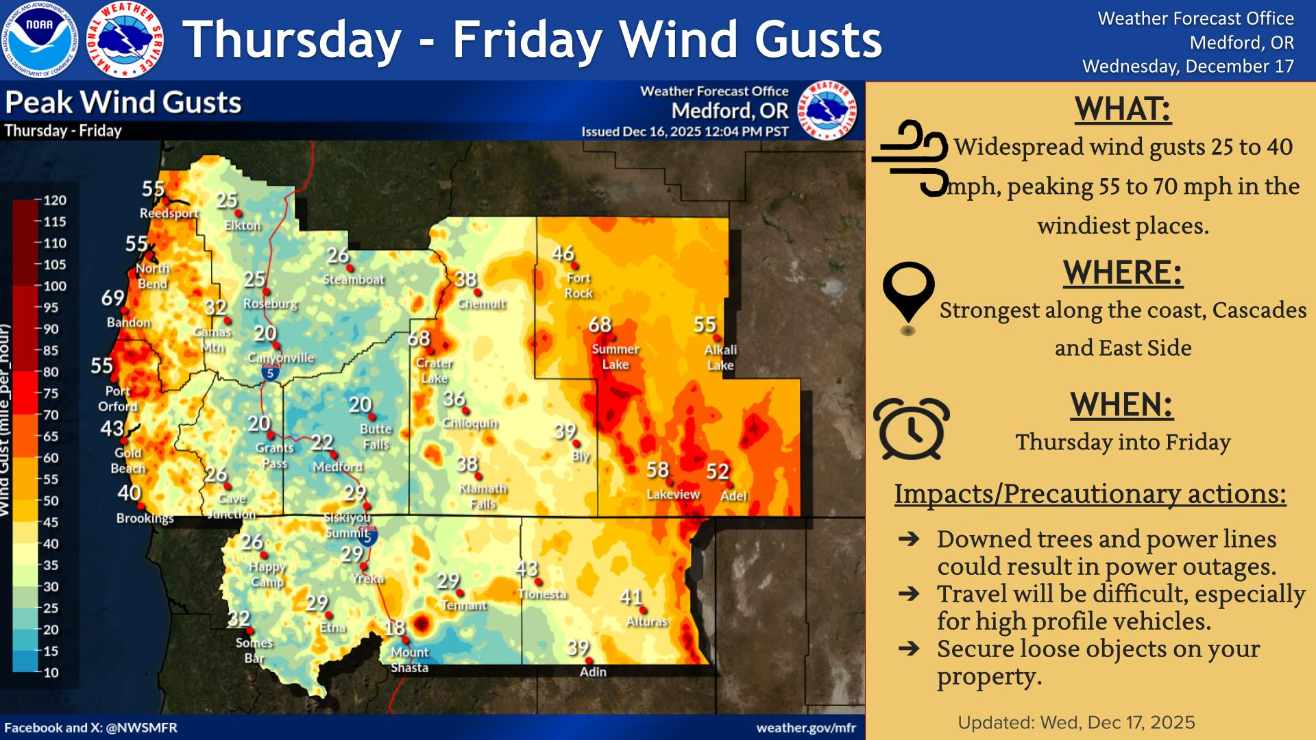
Widespread wind gusts of 25 to 40 mph are anticipated across the region, with peak gusts ranging from 55 to 70 mph in the most wind-prone areas. These conditions could make travel difficult, particularly for high-profile vehicles, and may result in downed trees, fallen branches, and powerlines. Power disruptions are possible in some locations.
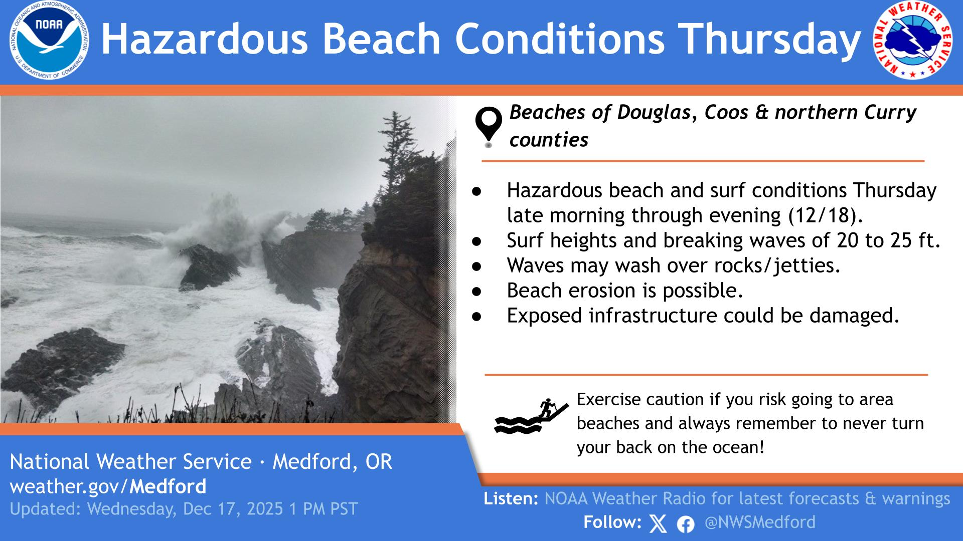
Along the coast and over marine waters, strong winds are expected to generate hazardous surf conditions. Breaking waves of 20 to 25 feet are forecast in the surf zone, with the potential for waves to wash over rocks, jetties, and into normally dry areas. Beach erosion is possible, and visitors are urged to use extra caution and never turn their backs on the ocean.
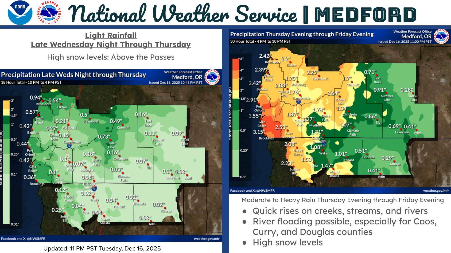
In addition to high winds and dangerous surf, a strong atmospheric river is forecast to move into the region Thursday evening and persist through Friday evening. This system is expected to bring a period of moderate to heavy rainfall, with the greatest impacts anticipated in Coos, Curry, Douglas, and Josephine counties. Rainfall totals in these areas could range from 2 to 5 inches.
Forecasters warn that ponding of water on roadways is likely, along with rapid rises on creeks, streams, and rivers. Mudslides and rockslides are possible in steep or recently burned areas, and there is potential for river flooding as the system progresses.
Residents and travelers are encouraged to continue monitoring forecasts and be alert for possible flood watches or warnings as conditions evolve.
Weather Messages & Alerts
Hydrologic Outlook
ORC011-015-019-033-182145-

Hydrologic Outlook
National Weather Service Medford OR
305 PM PST Wed Dec 17 2025

...Heavy Rain Expected in Coos, Curry, Douglas, and Josephine
counties...

An atmospheric river arrives Thursday night and persists through
Friday, bringing another round of moderate to heavy rain. Rainfall
amounts of 2 to 4 inches are expected, with the highest amounts
likely in Curry County. This is a slight decrease in rainfall
amounts as the focus of the atmospheric river lingers a bit longer
to our north before arriving in Douglas County and farther south.

Despite the slightly reduced rainfall expected, small streams and
creeks are still likely to run high and could result in nuisance
flooding along with ponding of water on roadways during periods of
heavy rain. Significant rises on mainstem rivers are expected, but
the overall concern for widespread river flooding is low at this
time due to antecedent dry conditions and minimal snowpack. We will
be monitoring rivers in the Coquille and Umpqua Basins for flooding
potential.

The exact scenario for flooding remains uncertain. This product will
be updated as necessary. Watches and warnings may be issued by the
National Weather Service if this situation worsens.
$$
Full list of watches, warnings, and alerts.
Cover image: Freepik